

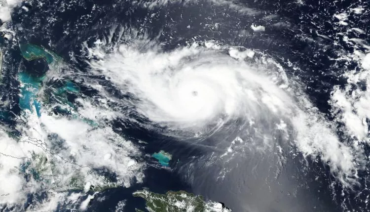
Washington, D.C. – In a landmark announcement, the National Oceanic and Atmospheric Administration (NOAA) has issued its most aggressive hurricane season forecast on record for the Atlantic basin. Due to unusually warm waters and a diminishing El Niño, NOAA predicts an exceptionally active year with 17-25 named storms, 8-13 of which could become hurricanes with winds of at least 74 mph. Among these, 4-7 could escalate into major hurricanes, boasting winds of at least 115 mph. This forecast surpasses the previous high of 14-23 storms predicted in 2010.

NOAA joins 15 other forecasting agencies and computer models predicting an above-average hurricane season, with most forecasts suggesting 20-25 named storms. This number could nearly or completely exhaust the list of 21 names for the 2024 season, requiring a supplemental name list. “These are a lot of big numbers,” said FOX Weather Meteorologist Ian Oliver. “None of which are very close to 14, which would be considered the seasonal average.”
Both NOAA and CSU point to the status of the Pacific Ocean’s El Niño-Southern Oscillation (ENSO) as a key factor. Current sea surface temperature readings no longer show a strong El Niño, which means that the tropical cyclone hindrances typically associated with El Niño will not be prevalent in 2024. During a typical El Niño, the Atlantic tends to have cooler water temperatures and more wind shear, which are less favorable for cyclone development. However, continued record warm water temperatures in the Atlantic and a neutral or La Niña climate pattern are expected to lead to a high number of cyclones.
Historic Forecast and Risk Analysis
NOAA’s forecast reflects an 85% chance of an above-average season, marking what would be the eighth such season in the past decade. A critical metric in NOAA’s arsenal is the Accumulated Cyclone Energy Index (ACE), which amalgamates the intensity and duration of all named storms. This year’s outlook predicts ACE to range between 150% to 245% of the median, thus classifying the season as “hyperactive.”
Dr. Phil Klotzbach, a senior research scientist at Colorado State University (CSU), echoes NOAA’s concerns, stating, “The Atlantic is still record warm in the tropical Atlantic, providing more fuel for storms.” CSU’s forecast aligns closely with NOAA’s, anticipating up to 23 named storms.
The Role of El Niño-Southern Oscillation (ENSO)
Both NOAA and CSU emphasize the influence of the El Niño-Southern Oscillation (ENSO) on this year’s hurricane activity. Current sea surface temperature readings no longer indicate a strong El Niño, which typically hinders cyclone development in the Atlantic through cooler water temperatures and increased wind shear. Instead, the anticipated neutral or La Niña conditions, coupled with record warm Atlantic waters, are expected to foster a higher number of cyclones.
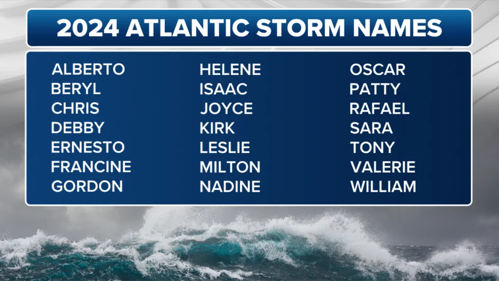
FOX Weather Meteorologist Ian Oliver noted, “These are a lot of big numbers, none of which are very close to 14, which would be considered the seasonal average.” The consensus among 15 forecasting agencies and models points to a busy season, with estimates suggesting 20-25 named storms, potentially exhausting the 21-name list for 2024 and necessitating a supplemental list.
Regional Impact and Preparedness
While the forecasts do not specify which U.S. cities might be most at risk, they provide regional risk insights. The CSU outlook indicates a 62% chance of a major hurricane making landfall along the U.S. coastline and a 66% chance in the Caribbean. Coastal U.S. states face a 10-20% higher than average chance of being impacted, implying potentially more significant effects compared to 2023. Last year saw one of the least impactful hurricane seasons in nearly a decade, with only one hurricane making landfall in Florida.
Meteorologists stress the importance of preparedness. “If you live on the coast, you have to be prepared to be impacted by a hurricane, and it only takes one,” said FOX Weather Meteorologist Britta Merwin. “It doesn’t matter if it’s an overperforming year or an underperforming year. If you get impacted, it will be the worst hurricane season you have been through.”
Moving Forward: Legislative and Community Responses
NOAA’s aggressive forecast underscores the need for robust preparation and response strategies at both the governmental and community levels. Coastal regions are urged to review and update their emergency plans, ensure the availability of supplies, and stay informed through reliable weather updates.
Community leaders and policymakers are also called to action, emphasizing the importance of readiness and resilience in the face of potentially severe weather events. The collaboration between meteorological agencies, local governments, and the public is crucial in mitigating the impacts of what is predicted to be a hyperactive hurricane season.
As the 2024 hurricane season approaches, the heightened predictions serve as a stark reminder of nature’s unpredictability and the necessity for preparedness. With NOAA and CSU providing detailed forecasts and insights, communities along the Atlantic basin are better equipped to face the challenges of the upcoming months.